Welcome to Adventures on Venture, the continuing story of our adventures and misadventures as we sail around the outside of this wonderful country, Australia!
It's a cliché but the Whitsundays really is a paradise of sandy beaches, colourful reefs and glorious weather.
From Goldsmith, we headed over to the south east anchorage at Lindeman. The anchorage is somewhat exposed to the south east trade winds but sheltered to a large extent by Shaw island. The bay between the islands is huge, deep and calm making it a very nice place to visit.
Lindeman itself has a failed resort on it which we didn't visit this time round but we did break out the hammock for a while on the beach.
We thought we'd give Hamilton Island a go next so we spent a couple of hours motoring in less than 10 knots of wind to get up there. It took a while to get into the marina as you have to be escorted in so we watched a couple of planes land. It's a nice place! Expensive and geared for tourists but worth a short visit. Nice bakery and free buses that do a circuit of the island hop on hop off style.
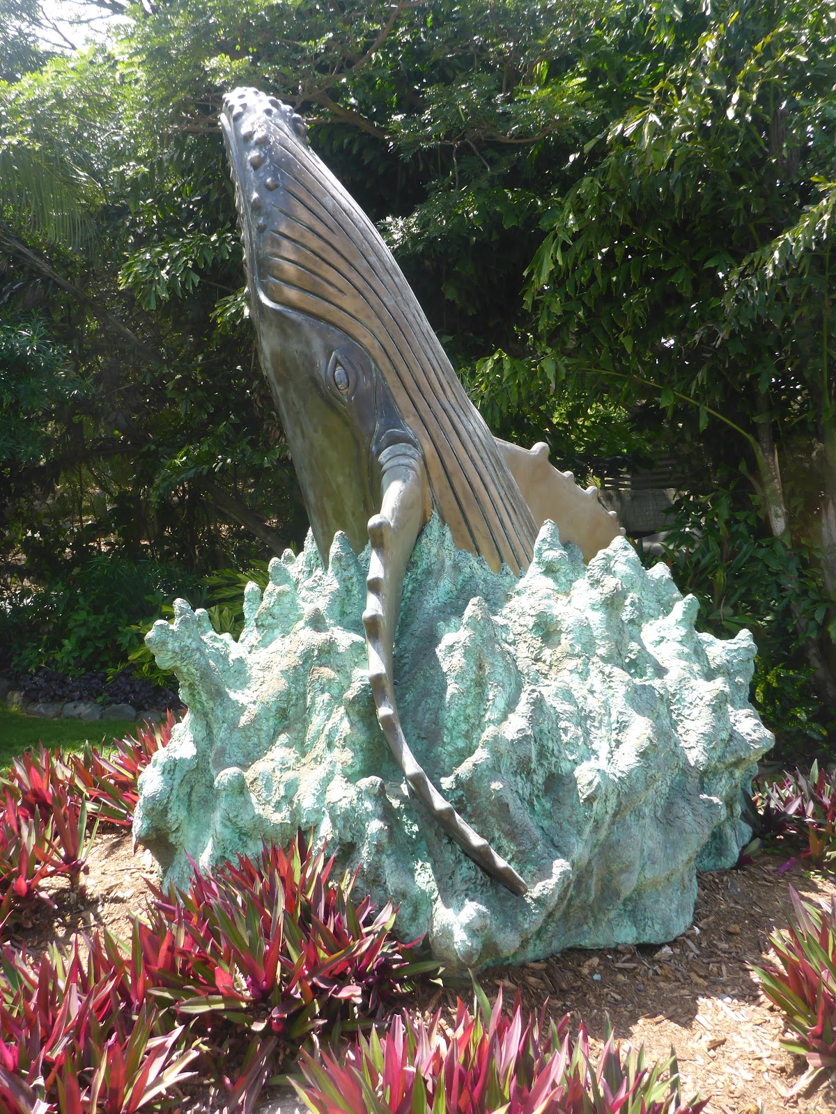
There are some pretty awesome sculptures on display and for sale on the main street!
Just before full dark, hundreds of bats start moving around.. We tried to get some photo's but it's impossible to capture them at least with the Lumix camera we had with us. Here's the best of our attempts :-) The dark blurs are bats believe it or not :-)
The marina looks pretty cool from the pub balcony at night! Nice fish and chips too! Terry played the pokies while I drank the ale :-)
From Mackay, we headed north into the Whitsunday group of islands for the second time.
First stop was the Scawfell in the South Cumberland group of islands. The crossing was a good one and we sailed almost all the way. The anchorage is a deep bay on the North West side of the island with good protection from the trade winds. It took two attempts to anchor and we stayed two nights in the end along with 5 or 6 other boats including SeaSay who we have shared anchorages with before. Crystal clear waters and a lovely beach.
We took the dinghy into the beach and had a bit of a walk around.
Entering the anchorage at Scawfell Island
Absolutely deserted beach at Scawfell Island. A beautiful spot!
Dry creek just off the beach
We followed it inland a bit till it got too rough for our old legs.
Lonely dinghy on the beach
And lonely Dave :-)
I had to help Terry the artist with this.. It's something we've done in a few places now and I find it fascinating to find the balance points of different rocks. Good fun!
A curious mix of physics and art
We moved on to Brampton Island which was where we met a whole bunch of butterflys last time we came through. It's a lovely spot but quite eerie as the resort has been closed for years and so it's very neglected. We stopped in at Western Beach this time on the (you guessed it) west side of the island. The fringing reef is separated from the beaches by a narrow and shallow channel. After we anchored, a bunch of Macgregor trailer sailors came past us and went right over the reef into the channel behind and anchored there.
We hopped into the dinghy and went ashore. The tide was falling at the time and we planned to be away for a couple of hours which would have made it high tide when we got back so we pulled the dinghy up the beach a bit and put the anchor in the tree line. We followed a walking trail to Dinghy Bay on the south east of the island. It was a lot further than we thought :-) A lovely walk though. We've found Brampton to be a great spot to visit! It's a national park and the trails are easy to follow and reasonably well signed.
However, it took a lot longer than we thought so when we got back, the dinghy was about 100 metres from the sea. Bugger.. The beach there shelves really slowly so even after we'd dragged it down to the sea, we still had to drag it about 20 metres further before the bloody thing would float. We were both exhausted by the time we got back to the boat so we crashed and had a late tea.
Venture is out there somewhere :-)
Over the hill to Dinghy Beach
A walkway over one of the creeks
The following day, we headed off to Stingray Bay on Goldsmith Island.
This anchorage is on the south side of the island and we chose it because the expected weather overnight was 5 to 10 knots from the North. Boy did we get a surprise!
A front came through in the early hours and the wind swung round to the south at 20kts gusting 25 or more putting us on a lee shore in rising seas. We were woken by the anchor alarm at 2am and when we turned the instruments on, we found ourselves with 1m under the keel when we had anchored in 10m of water at near low tide! We decided to get out of there and head around to the other side of the island so we started the engine and headed up towards the anchor. We bumped the sand a couple of times as we headed out into deeper water.
I went forward and started pulling the anchor up while Terry stayed by the wheel. But I could not get the anchor to break free of the sea bed! The seas were mounting and the bow was pitching about 2 meters when the waves came through. I tried pulling on the anchor when the bow was down but as it came up, the chain was pulled back over the gypsy (see below). The anchor was properly wedged or the chain had wrapped around a rock. I gave up and went back to the cockpit to find Terry in a right state.. She had been panicking as it was pitch black and the plot showed rocks off the starboard bow but she couldn't see them.
We talked it over and decided she would go back to bed while I kept station over the anchor until daylight. The only other option really was to slip the anchor entirely (let all the chain out) with a buoy attached so we could pick it up another day. But I was confident that worst of the weather had passed us so I was happy to hang there until it calmed down again. Amazingly enough, Terry actually went back to sleep!
So I spent nearly 3 hours at the helm watching the plot and trying to keep the boat in one place over the anchor using the engine. It was actually not that difficult once I figured out that with the engine just above idle and left rudder, it basically sat there head to the wind. The engine just counterbalanced the wind and we were basically hove-to using the engine. Occasionally I'd have to give it a squirt of power to bring the bow back into the wind but on the whole, it was relatively easy, just really tedious..
In the morning, I got Terry up and we freed the anchor by giving it about 10 meters of slack and motoring slowly against the pull of the anchor chain. It didn't work first time round (clockwise) but second time round (anti-clockwise) it unwound from whatever it was stuck on and the anchor came up cleanly but with a 5 degree bend in the shank!
We went around the other side of the island to Western Beach and anchored again with a sigh of relief. I had a kip..
Our anchor winch.. The "gypsy" is on the right hand side with the chain going over it. The chain disappears into the anchor locker just behind and below the gypsy.
This was the track recorded on our plotter of the 3 hours or so I spent keeping station over the anchor.
The reef at Scawfell is extensive and we spent some time in the dinghy drifting over it trying to get a better look at a large fish playing near the surface but had no luck.
We did however, take some video as we drifted back into deeper water.
We left Rosslyn Bay and headed further north aiming for Mackay. As usual, we planned carefully to do the trip in small hops all during the day which meant some early morning departures but means we rarely (if ever) end up entering an anchorage in the dark.
We headed for Port Clinton first as we stopped just north of that anchorage in Pearl Bay last time we headed north. It's a large, well protected area with a lot of small shallow creeks but anchorages for all weather. We stopped on the western shore a couple of miles south of the entrance in 3 meters of water but expecting another 5 meters at high tide. Tides are getting much bigger now as we head north.
We only stayed overnight and in the morning moved on to Island Head Creek just 20 miles north. This is another large area with mangroves and creeks suitable for anchorage in all weathers. We stopped this time in the second inlet about 2.5 miles from the entrance. We put our nose into the first inlet but we were put off by very shallow water and with the big tides, we tried further down and found a nice spot just inside the inlet near the northern bank. There were a couple of other boats in there but nobody we knew and we wanted a rest before the next leg.
We stayed there for a few nights enjoying the peace, did some exploring of the creek and had a quite unsuccessful fishing expedition.
An unsuccessful fishing expedition. But they say you have to actually put the hooks in the water if you want to catch a fish.. Go figure..
At anchor in Island Head Creek
We headed off early for the 40 mile leg up to the Duke Islands. We decided to go the inside route this time as we visited the Percy's on the outside route last time.
Heading around Townshend Island, we hit 9.5 knots at one point in 15kts relative wind on the port quarter but that was in a 2 knot northbound current :-)
We anchored in a beautiful spot behind Hunter island which looks quite exposed but is well sheltered from the SE Trades. We headed into the beach for sundowners and toasted an absolutely glorious sunset behind Venture at anchor.
A toast to the cruising life!
From the Duke islands, we headed up to a small island called Curlew 30 miles north west. The anchorage off the northern beach was lovely but the trades were blowing hard and we spent an uncomfortable night with 25kt bullets (sudden wing gusts) coming over the hills and a fair swell coming around the southern point. So we only spent one night there and headed off to Mackay the following morning.
The trip over was very rolly with the wind on the port quarter and not quite enough to stabilise the boat against the easterly swell. But we did manage to sail most of the day with the engine off.
As I said in the last post, we were only there for one full day before we had to leave due to predicted strong northerlies. The anchorage is protected well at low tide but the swells come right over the reef at high tide so it can be quite uncomfortable in strong winds at high tide. So I'm told that is, we didn't hang around to find out :-)
The island is a real treasure! A coral cay just 35 miles East of the common jump off point at Pancake Creek. The island itself is sand with a lot of trees and we took a walk right around on the beach.
We didn't get into the water there unfortunately as the wind had picked up but next time, we most definitely will! The reefs look magical and the water was crystal clear when we anchored, not so much the next day though.
We did get onto the island though for a walk around. In fact, we did walk all the way around and through the middle :-)
Lady Musgrave Island
Not exactly a clean wake!
A lovely walk through the interior of the island
Black Noddies in the trees. Lots of them!
Beach on the Northern side of the island
View of the anchorage from the beach
It was a trial getting the dinghy back to the water.
We left Bundy at dawn (sorry Terry) for the long trip north to Pancake Creek. 64 miles at an average cruising speed of 5 knots makes for a very long day and to get there in daylight meant we had to really push things along.
We made it in just over 11 hours in the end at an average speed of 5.9 knots. Motor sailed most of the way with less than 10 knots of wind from the south-east (right over our right shoulder) but we managed to turn the motor off for about 2 hours or so during the trip. A very roly day on the water.
Pancake creek is a nice anchorage and we had fond memories from the last time we were there but this time round, it took three goes to get the anchor to hold! The first two times in different places we hit rock shelves and trying to set the anchor just gave rumbling noises as the anchor dragged over the rock. We got it to set at the third attempt finding some sand deep enough to grab. Both of us were a bit pissed off by the end of the exercise but we were heartened when the next boat in had similar trouble :-). We had pancakes for tea!
After tea, I expected to have hot water after running the engine most of the day but no, the system I set up to heat the water from the engine had failed! A pump I bought to circulate water from a heat exchanger through the hot water tank stopped working and was blowing the in-line fuse. It's a year old and dirt cheap but still.. Bugger.
We spent three nights there in the end with "sundowners" on two different sand banks. It's an odd feeling to be sitting down drinking wine with fellow yachties and you find yourself surrounded by water as the tide comes in. In the end, it's a bit of a rush to get everything packed away in the dinghies to get back home before the chair legs get wet.
Sundowners on the sand bank at Pancake Creek
Nothing happening here!
From there we headed out to Lady Musgrave. We missed this stop the last time we came north due to weather conditions so we were determined to get there this time. It's the southernmost coral cay in the Barrier Reef chain and part of the Capricornia group of islands. A magic spot with an island at one end of a huge lagoon surrounded by coral reefs.
I had a cunning plan. It went, we head off from pancake creek and sail to Lady Musgrave arriving just at slack water on the low tide. Slack water because the lagoon empties through a very narrow channel so going in on an ebb tide is a bit dodgy. So we dawdled along with me feeling quite smug as another boat that left before us headed off at top speed.
We arrived next to the reef entrance about 1 hour before low tide at 16:00. Nope, this wasn't part of the plan, it was a screw-up. The sea around the entrance to the channel was a totally confused mess with eddies and whirlpools. At that time, I figured out that the tide app on my phone was an hour out for some unknown reason as it's been pretty accurate all along. An hour till low tide and another hour before the flow subsided meaning if we waited, we would be anchoring in the dark amongst coral outcrops.
So, we headed into through this really narrow channel with thousands of tons of water headed the other way. It was probably the absolute worst time to enter the lagoon and decidedly dodgy! About 50 meters before we entered the channel, Venture was turned through almost 45 degrees one way and then the same again in the other direction due to one of the eddies. It was really tricky holding a straight course through that mess. After some heart-stopping moments, we entered the channel with the engine at top speed making about 1.5 knots over the ground and close to 7 knots through the water!
Inside the channel, the water stabilised into a lamina flow so no more fighting the wheel, just a very slow passage over about 100 metres of maybe 15 metre wide channel and that was when we saw what makes the lagoon waters so special. We could clearly see the coral on either side sloping off down to the sandy bottom about 8 meters below us. The water was like glass, an absolutely amazing sight!
We were both gob smacked all the way up through the lagoon to the anchorage. You could see the coral outcrops clearly and it was quite easy to find a big patch of sand to put the anchor down. I could watch the anchor settle on the bottom, 7 meters below us and as I paid out the chain, I could see it turn over and start to dig in.
Through all this, we took not one single photo! We were both stunned but thought that the conditions would be the same the following day so we basically lazed around and planned what we would do the next day.
Then the weather changed. For the whole of the next day it was blowing at about 10 to 15 knots and cold, the sea was choppy and there was a swell running especially when the reef was covered at high tide. We knew we would only have one full day there as there was some bad weather coming and the lagoon can be a very uncomfortable place in a developed strong wind. We did take the dinghy to the beach and had a nice walk around and across the island but no snorkelling. Bugger.
A pretty poor panorama of the beach at Lady Musgrave
We left the next day and headed back to Pancake Creek to wait out the predicted northerly blow before heading north again. The cunning plan was a total bust! If we had not dawdled over, we would have had a much easier passage through the channel and the afternoon to mess about in the glass like conditions but no, too clever by half.
We spent another couple of nights in the creek before heading off at dawn again (sorry Terry) for Hummocky Island, just on the other side of the tropic of Capricorn. The tropics. We celebrated by having a tipple of (what I thought) was Dubliner (whisky liqueur). Terry took one sip and nearly spat it out. I'd poured McAllister (cheap mixing scotch) instead :-) After hunting through the boat for at least 10 minutes, we finally came up with the bottle of Dubliner which Terry had put in a very safe place and had our "cheers" moment!
Crossing into the tropics. Cheers!
Funnily enough it was just as cold on the northern side of the tropic of Capricorn as the southern side.. Go figure.
The weather forecast let us down this time. We chose to go on a day with some nice strong South Westerly winds which would put Venture on a beam reach in perfect sailing conditions but by the time we left, the forecast was downgraded to only 5 to 10 knots and that was what we got. The motor was on almost the whole way yet again.
On the way, we crossed the tropic of Capricorn and entered the tropics.
Venture at Hummocky Island.
The rocks on the left here looked a lot closer from the boat!
Hummocky Island was nice! A big bay on the northern side of the island with good clean sand for the anchor and protection from the expected strong southerly overnight. On the way in, we saw some big sea caves so we dropped the dinghy and motored around to have a look inside.
With torches in hand, I turned the dinghy round and backed slowly towards the first cave. There was about a 1/2 meter swell running and it was quite disconcerting to see this hill of water disappear into the cave and the surge was quite strong. I was just getting the hang of balancing the motor against the intermittent surge to slowly move backwards into the cave when there was this loud hollow boom somewhere inside the cave. It was really quite eerie. So we chickened out and motored around to the other cave. This one had a wider opening and looked more promising except the roof sloped down to a small opening at the back maybe 10 meters inside the cliff face.
The opening was about 3 meters wide but the surge
and weird booming noises were a bit much for us brave souls
This one was wider but not very deep into the cliff face
except for the tiny opening at the back
Not quite the adventure we expected. Terry was wearing a head band torch the whole time but we never got out of the sunlight :-)
Daryl and Ruth were in the anchorage with us in their boat so we had sundowners on the beach. Daryl and I swapped stories while Terry chased Max (2 and bit) all over the place. Nibbles and wine were consumed until well after sunset. Both Max and Terry slept well that night but I hung around in the cockpit trying to figure out if we were getting closer to the rocks as the tide dropped.
Sunset at Hummocky Island
At one stage, I was using a narrow torch beam, a level app on my phone and the formula "tan Θ = distance_to_rocks / height _above_water" (I'm a tech head, what do you expect!) to figure out the distance. I discovered that it's really tricky to hold a phone on top of the torch as high as possible while simultaneously pointing the torch at the rock and reading the angle on the phone on the back of a moving boat! After 3 attempts I averaged out the results and came up with 30 meters! The plan was to repeat it an hour later but I fell asleep in the cockpit. Math is fun but a laser range finder would be so much better :-)
The following day we headed off to Rosslyn Bay for some provisioning and another couple of odd jobs. Another motor sail in 5 to 10 knot breeze. We are really putting some hours on our new motor!
Sunset at Roslyn Bay (Keppel Bay Marina)
Highlights: Some nice sailing up the coast and crystal clear water at Musgrave
Lowlights: The engine water heater failed. Bugger.
For those that are interested, here's our current track Northbound since we left Tweed Heads. It should open in Google Earth..